Research and Scientific Activities
1. New Earthquake Design Method
In the 1995 Kobe Earthquake, numerous civil engineering structures and buildings suffered from enormous damages. The direct cause of the severe damage was the extremely strong earthquakes motions in the near field from of an inland active fault, which had not been considered in the earthquake-resistant design before the earthquake.
After the earthquake, a goal was set for earthquake resistant designs to protect the structures and buildings from totally collapsing even against strong earthquake ground motions, and to save lives. For that, the performance-based designs methods against 2 level earthquake ground motions were recommended.
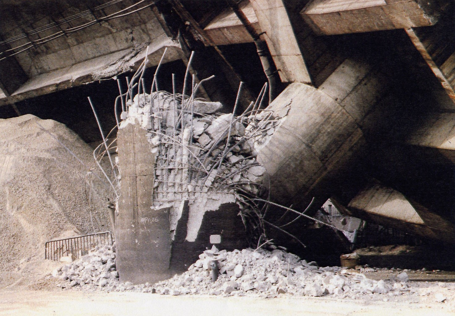
Image 1: The highway piers collapsing in the 1995 Kobe Earthquake
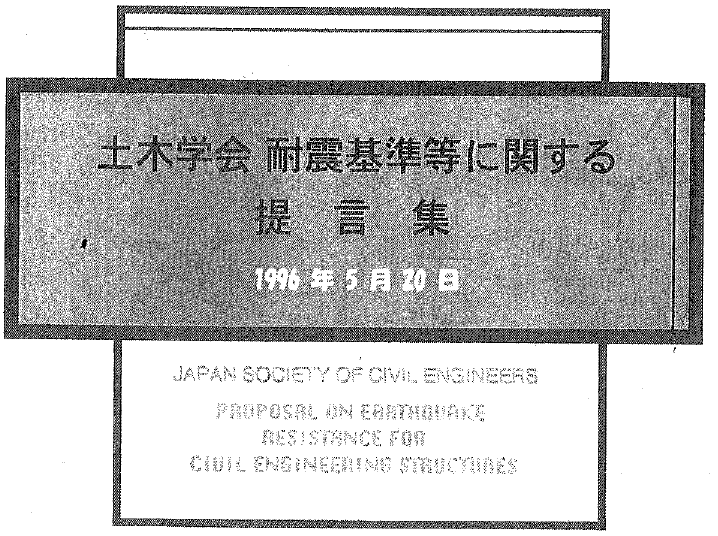
Image 2: Japan Society of Civil Engineers formulating earthquake design methods
2. Development of earthquake design method for underground structures
Based on the earthquake observation results and model tests of large underground structures such as subsea tunnels and inground tanks for oil and gas, an earthquake design method was developed, so called response displacement method using and earthquake design procedures and guidelines for various underground structures such as buried pipes and foundations were prepared.
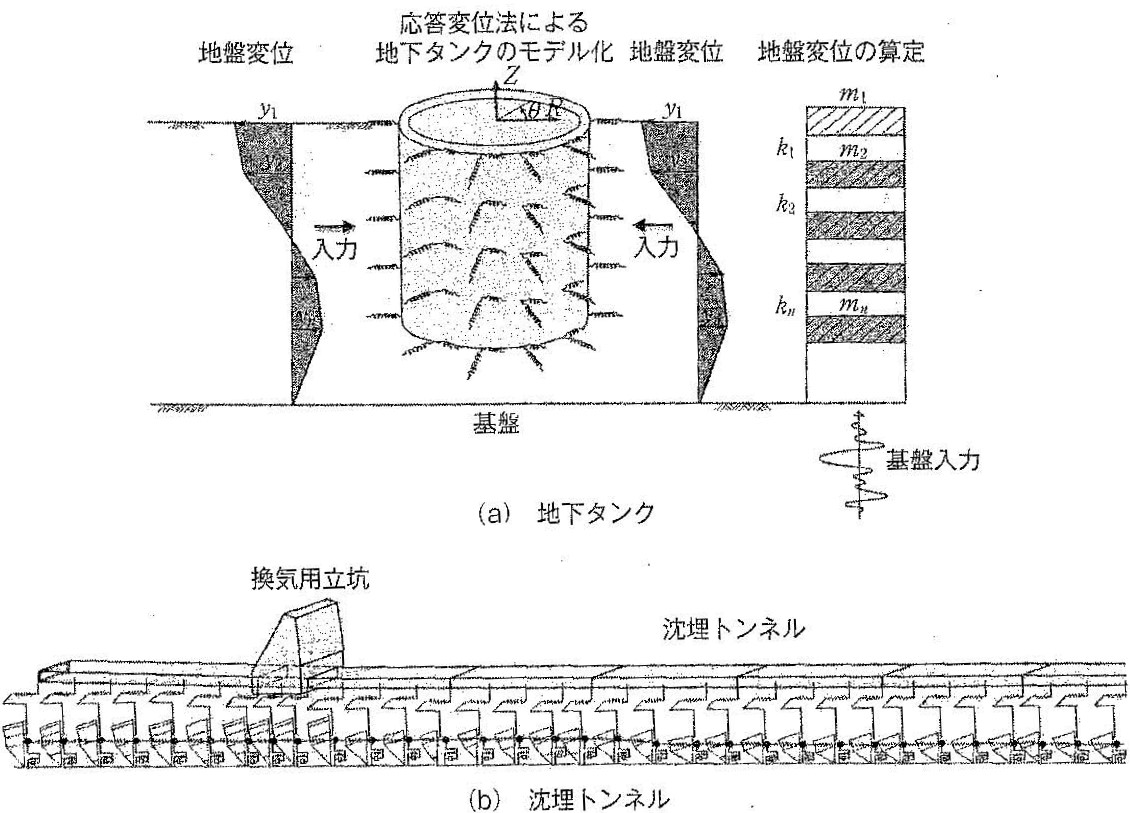
Earthquake design model of inground tank by response displacement method
3. Study of soil liquefaction and lateral ground movement
3-1. Measurement and analysis of large ground displacements due to soil liquefaction
The phenomenon of lateral movement of the liquefied ground of several meters, was discovered for the first time in the world, following the investigation of the 1983 Japan Sea earthquake, and a quantitative survey of the ground displacements was conducted. Later, lateral ground movements were measured by The 1923 Great Kanto earthquake, The 1948 Fukui earthquake, The 1964 Niigata earthquake, the 1971 US San Fernando earthquake, The 2010 New Zealand Darfield earthquake, and The 1995 Kobe earthquake. Furthermore, the liquid properties of the liquefied soil were studied, and methods for the prediction of the magnitude the ground displacement were developed.
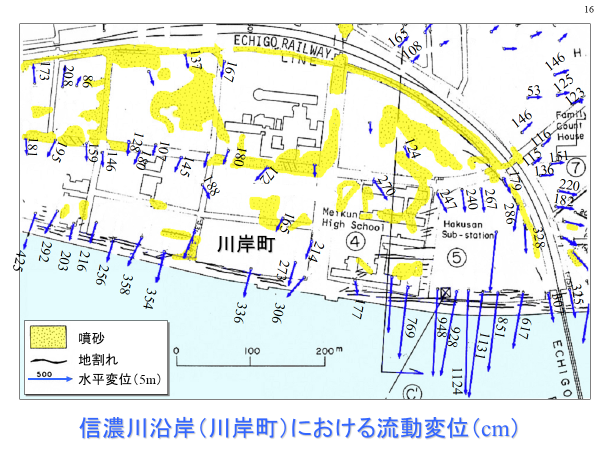
Ground displacement along the Shinano River in the 1964 Niigata Earthquake
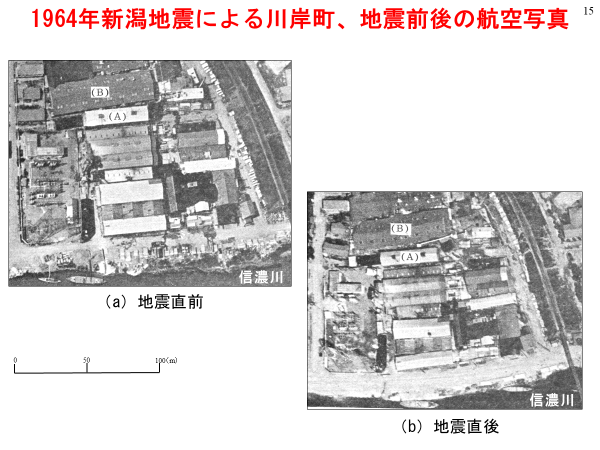
Post-earthquake situation on the Shinano River coast
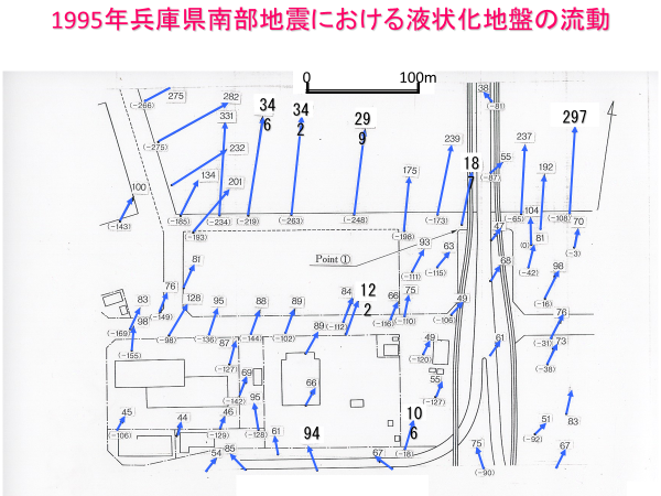
Ground displacement in northern Rokko Island in the 1995 Kobe Earthquake
3-2. Development of lateral flow ground displacement restraint method
In order to protect waterfront industrial parks such as The Tokyo Bay, The Osaka Bay and Ise Bay from lateral ground flow, developed countermeasures against ground displacements were developed. Among these methods, the effectiveness of the method of driving steel pipe piles at intervals was confirmed by the model test under centrifugal condition, numerical analysis, and observations of the pile foundation in the actual ground. Compared with the ground improvement methods, this method is not only advantageous in terms of construction cost and construction period, but also has an advantage for the construction works in narrow areas of existing industrial plants.
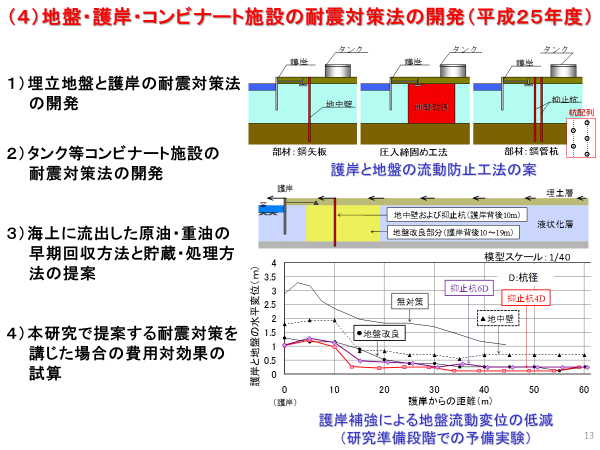
Verification of the effect of the countermeasures against ground displacement
3-3. Development of liquefaction countermeasure method for houses
In the 2011 Great East Japan Earthquake, a number of ordinary houses were sunk and inclined by liquefaction in a residential area newly developed on the lands reclaimed from the Tokyo Bay. Housing development in landfills is being promoted around the urbanized areas of Japan, but there are few cases where liquefaction measures are being implemented. In existing general houses, it is almost impossible to take measures against liquefaction by driving piles and improving the ground, from the viewpoints of construction costs and the living during the construction works. Therefore, countermeasures were developed for existing houses by light steel sheet piles surrounding houses. The construction cost is much lower than that of the ground improvement method, and it has the advantage that construction can be done while living.
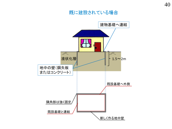
Liquefaction measures for houses by enclosing steel pipe piles
3-4. Research of islands sunk by soil liquefaction
In 1586, a magnitude 7.2 inland earthquake struck Beppu Bay, Oita Prefecture in Kyushu Island, and it is said that about 1,000 people sank to the seabed. Whether it is a fact or a mere legend, it is still uncertain. Using the training ships of the Marine Department of the Tokai University, Bosei Maru and Tokai University Maru II, the seabed of the Beppu Bay for two years was surveyed. As a result, there had been an island called "Uryujima" about 4 km offshore of Beppu City at present, but it is inferred that the island sunk due to the extensive soil liquefaction of the seabed and the seabed sliding. However, since the disaster occurred more than 400 years ago, there are only a few records of highly reliable documents and there is no clear evidence to confirm its authenticity.
However, the 1999 Luzon Earthquake in the Philippines caused large-scale subsidence of a sandbank in the northern Gulf of Lingayen Bay. About 1,000 people lived at the time of the earthquake. Many sand boils and ground fissures caused by liquefaction were observed on the ground surface that remained slightly above the sea. Liquefaction is presumed to be the cause of the large-scale settlement and slope sliding of the sand banks.
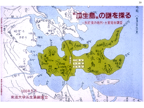
An old map of Uryujima, which is said to have existed in Beppu Bay
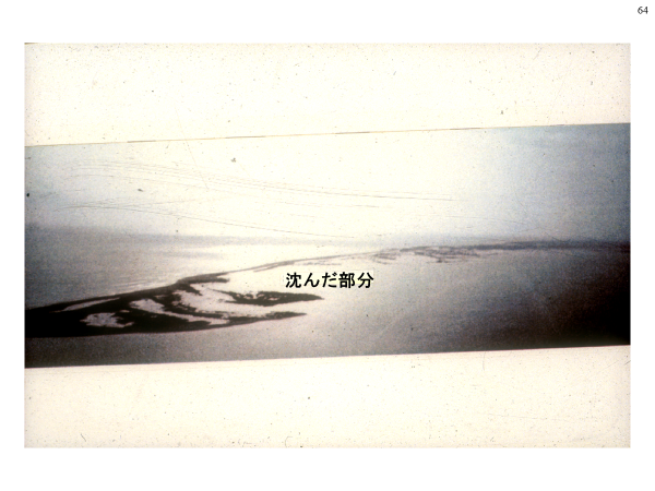
Philippines Linggaen Bay Sandbank (partially submerged)
3-5. Promotion of US-Japan joint research on soil liquefaction and lateral ground movement
Regarding the lateral ground flow of liquefied ground, research was conducted in the United States mainly by Professor Thomas D. O'Rourke of Cornell University. In the 1906 San Francisco earthquake, the ground moved a few meters horizontally in Mission Creek, a reclaimed land in the eastern part of San Francisco, according to an analysis of road photographs taken after the earthquake.
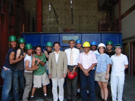
Based on the results of research in Japan and the United States, with the participation of researchers from Canada and New Zealand, a Japan-US workshop "Liquefaction, large ground Displacement and Earthquake Resistance of Lifeline Systems" was firstly held in 1986 in Tokyo and it was held 8 times over a period of 10 years in U.S. and Japan. In addition, joint experiments were conducted by the students of Waseda University and the University of California, San Diego to study the mechanism of lateral ground flow, and to develop a method of prediction of ground displacements.

Japan-US workshop on the large ground displacement of liquefied ground and earthquake resistance of lifeline systems
Joint experiment with Waseda University and the University of California San Diego

A Case studies on lateral ground flow and seismic resistance of lifeline systems
4. Earthquake and Tsunami Resistance Enhancement of Industrial Parks
4-1. Establishment Institute of Disaster Mitigation of Industrial Complexes
The Institute for Disaster Mitigation of Industrial Complexes was established in 2014 to promote the reinforcement of industrial parks such as oil refineries and power plants constructed on the reclaimed lands. The purpose of the foundation of this institute is to develop construction technologies for the improvement of the industrial facilities, and technical guidelines for the earthquake and tsunami disaster prevention, and to provide technical supports for disaster prevention national projects. "Consortium for Oil Supply Structure Upgrading Project" was organized by the institute, and has been reviewing the policy to stabilize the oil supply at the time of disasters by the Ministry of Economy, Trade, and Industry since 2014.
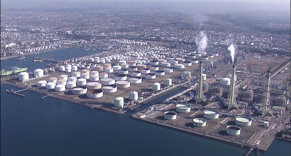
Promotion of Reinforcement of Oil Refining Plant
4-2. Study on the safety of abandoned coal mines
Abandoned coal mines are widely distributed mainly in the central region of Japan, and there have been many incidents due to collapses of deteriorated columns of caverns. Since 2002, surveys have been conducted for Mitake Town in Gifu Prefecture, Japan, and maps of the location and the depth of the caverns were published, and water predicting the number of collapses of caverns by the future Tokai and Tonankai earthquakes, and the damage to lifeline systems such as power supply.
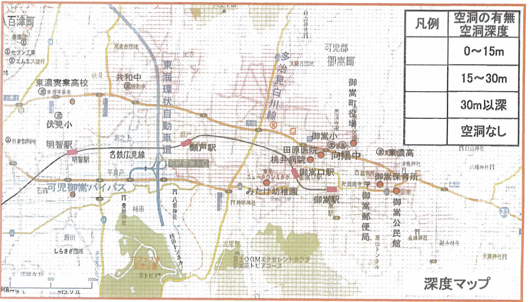
Map of the location and the depth of abandoned coal mines in Mitake Town, Gifu Prefecture
5. Investigation on Earthquake Damage and Technical Assistance to Recovery
5-1. Japanese Earthquake
Site surveys were carried out on the earthquake disasters that caused the deaths and missing people after the 1995 Kobe earthquake, and the cause of damage was investigated.
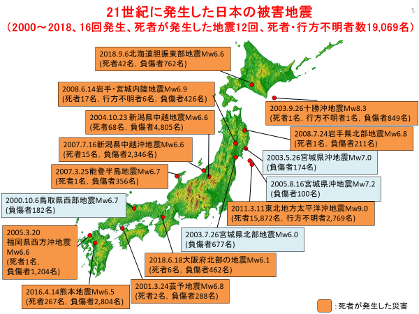
Japan's earthquake and tsunami disasters since 1995
5-2. The world
Since the 1995 Kobe earthquake, the field surveys of the earthquake and tsunami disasters that caused more than 1,000 death and missing than 1,000 missing, were carried out. The survey results are available to the public in the reports from the Japan Society of Civil Engineers and others.
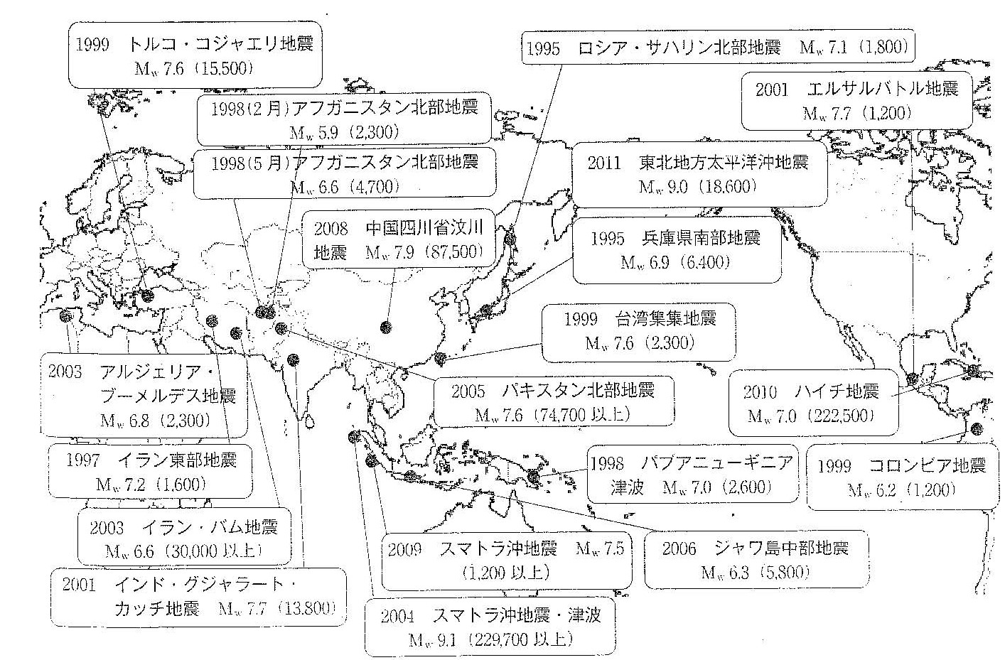
Earthquakes and tsunamis around the world (disasters that have killed or left more than 1,000 people dead or missing since 1995)
5-3. Technical Assistance for Recovery from Disasters
Technical supports for the recovery and reconstruction of disasters-affected areas have been provided around the world.
1990 Luzon Philippines Earthquak
1990 Luzon Philippines Earthquake: occurred on July 16, 1990, causing damage due to liquefaction, mainly in Dagupan City in the northern area of Luzon Island. Twenty jacks were transported from Japan to Philippines for the recovery of an inclined five-story reinforced concrete building under the technical guidance of Japanese professional engineers. As shown in the figure. The building of the university in Dagupan City is still in use.
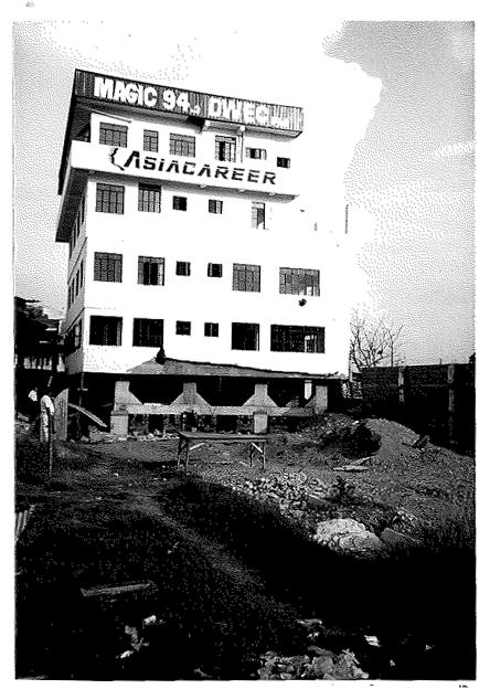
A five-story reinforced concrete building, inclined and sunk by the soil liquefaction
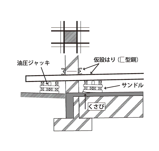
How to recover
2004 earthquake and tsunami disaster in the Indian Ocean
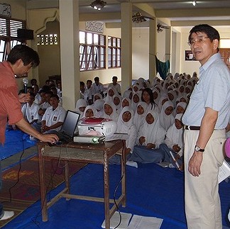
After the 2004 earthquake and tsunami disaster in the Indian Ocean, a tsunami warning system was proposed for the northern part of Sumatra by engineers from JSCE, and technical guidelines for the reconstruction of the west coast road of Sumatra was recommended to the Indonesian government. The tsunami warning system will monitor earthquake ground motions on the west coast of Sumatra along the Indian Ocean to determine whether or not a tsunami is generated, its height and the arrival time, and warns local people through minarets (spires used to broadcast the Quran to the surrounding areas in the morning as well as evening) at mosques throughout the northern Sumatra.
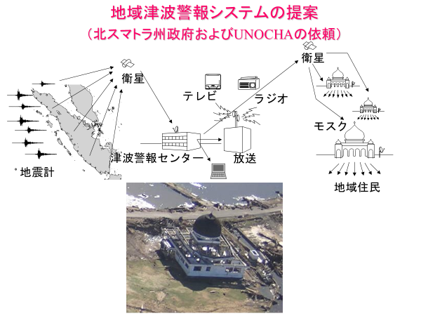
Proposal for the Sumatra Tsunami Warning System
2008 Wenchuan earthquake, China
The 7.9 magnitude Wenchuan earthquake that struck on 12 May 2008 left more than 87,000 people dead or missing in China. Many buildings in and around Chengdu, the provincial capital, collapsed or slumped due to strong earthquake ground motions. Photo 9 shows a six-story apartment building in Dujiangyan, where the first floor pillars were severely damaged at their joints with the beams. The restoration plan for this building was proposed by the JSCE team as shown in the figure, referring to the experiences from the 1995 Kobe earthquake, and the restoration work was carried out according to plan. The building is still in use as a housing complex.
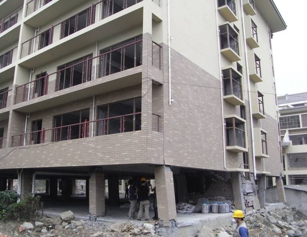
The damage to buildings (2008 Wenchuan earthquake, China)
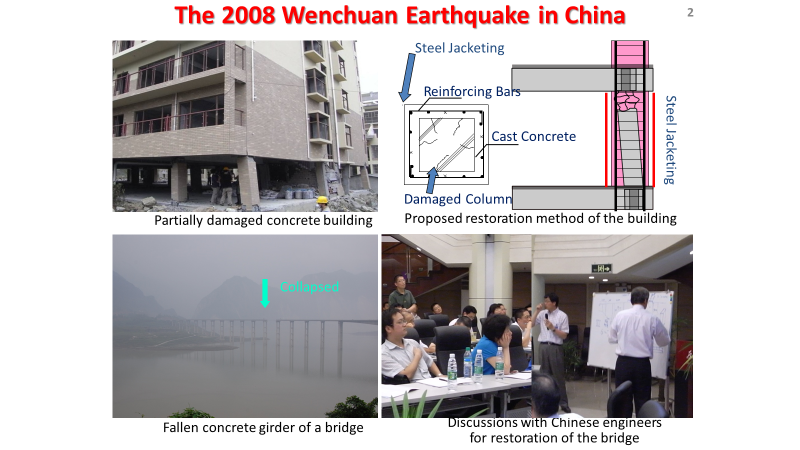
How to recover